
The multi-town effort to manage invasive species, including knotweed, continues to yield benefits and data in The Valley. Last week local knotweed warriors from Warren, Waitsfield and Fayston along with the UVM interns working here this summer met with two UVM staff to take a look at some high-res images of local flood plains, river banks and knotweed infestations.

Hans Estrin, UVM extension ecology planning lab coordinator, and Adam Zylka, UVM engineer with the spatial analysis lab (SAL), were in The Valley on August 8 to deploy two different types of large drones that captured extremely high-resolution images of the Mad River and its watershed from 400 feet in the air. The pictures are so high resolution that they provide specific species data and can be used to assess vegetative changes over time in specific areas, Estrin explained.
“For communities like Warren, Waitsfield and Fayston that are working together to come to grips with invasive species, this work helps them visualize their progress over time, like a scoreboard,” Estrin said.
“This work is all new in that SAL is doing this work throughout the state and it’s a bit of a windfall for The Valley because of the quality of the images. These are very high-res pics stitched together with geothermal overlapping which show the whole spectrum for infrared and ultraviolet on maps,” Estrin said.
Two different drone flights took place. The first was the infrared/ultraviolet drone and the second was a LIDAR drone which sent laser waves into the vegetation and sediments showing what was growing and what has been deposited on a site, including flood plains.
“This lets people see the impacts of their work and the impacts of flooding,” Estrin pointed out.
“Over time, it can show historically how flood plains and rivers move,” he added.
Warren Conservation Commission chair Jito Coleman, one of the leaders and founders of the three-town conservation commission effort to address knotweed, said that the UVM SAL drone mapping was a great tool for assessing the multi-town efforts both in terms of what is happening along the river corridor and in flood plains.
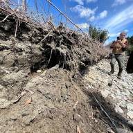
“The aerial view helps us see if our efforts to reduce knotweed at higher elevations, so it doesn’t wash downstream in flooding events, is working. And it helps along the river corridor itself because in some places the knotweed infestations are so dense that we can’t walk along the river banks,” Coleman said.
This type of imagery – and access to these tools through UVM -- help local conservation commissions and volunteers see and draw knotweed boundaries, Coleman explained.
“Over time we believe that not only will it show us how the river is moving on a minute level, centimeter by centimeter and year by year, but also show us if it moved where the knotweed is or isn’t and where the knotweed is going. We know that knotweed has shallow roots. We believe, and the science strongly supports the belief that knotweed accelerates erosion, so knowing where it is and how it’s impacting the river is critical,” Coleman said.
Coleman said that the increasing amount of rain that Vermont is receiving and the increasing number of flood events makes cataloguing data even more important.
“In this part of Vermont, a 100-year flood is one that has been defined as 5.5 inches of rain in 24 hours. We know now that those numbers no longer reflect what we’re seeing,” he said, referencing a 100-year flood in July 2023, December 2023 and July 2024.
“That means that those numbers, which were used to design our infrastructure, are no longer good by a factor of two or three or more,” he pointed out.